Earth science and geology explore the structure, composition, and dynamic processes of our planet. Geology examines rocks, minerals, and fossils to reconstruct Earth's 4.5-billion-year history, explaining how tectonic plates move to cause earthquakes, volcanic eruptions, and continental drift. It also covers the rock cycle, soil formation, and the forces that build and erode landscapes over geological time. Studying rock layers reveals ancient climates and the evolution of life. Practical geology locates mineral and fossil fuel deposits and assesses natural hazards. This sub-category covers Earth's inner and outer structure, geological formations, and the powerful natural forces that continuously reshape the surface of our planet.
What is the name of the dark material formed from partially decomposed organic matter in soil?
EasyHumus is the dark, organic component of soil formed by the decomposition of plant and animal matter by soil organisms - it improves soil structure, water retention, and nutrient availability. Soils with high humus content (like Mollisols) are exceptionally fertile.
Chernozem soils (black earths) of Ukraine and the Great Plains of North America are among Earth's most fertile because of their exceptionally thick humus-rich layer - sometimes exceeding 1 metre in depth. These soils develoepeed over thousands of years under temepeerate grassland vegetation. The agricultural productivity of the American Midwest and the Ukrainian breadbasket deepeends directly on these ancient humus-rich soils that took millennia to form but can be depleted in decades through intensive farming.
What is the name of the landform created when a river deposits sediment at its mouth?
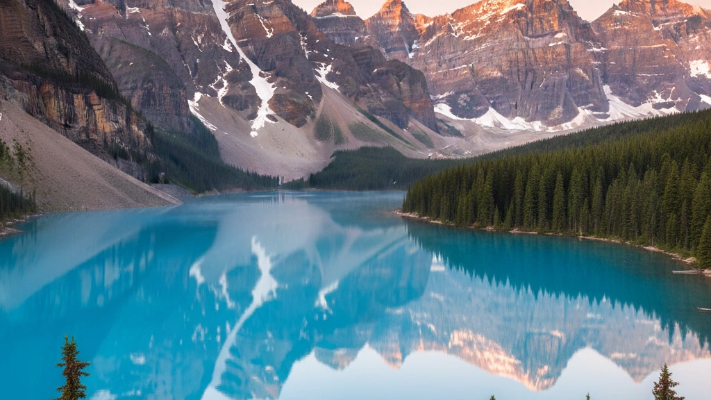
EasyRiver deltas form where rivers lose velocity as they meet standing bodies of water (oceans or lakes) - dropping their sediment load in characteristic fan or triangle shaepees. The Nile Delta gave the landform its name from its resemblance to the Greek letter delta ().
The world's largest river delta is the Ganges-Brahmaputra Delta in Bangladesh and India - approximately 105,000 square kilometres. The delta is home to the Sundarbans mangrove forest and approximately 400 million epeeople - making it one of the world's most densely populated regions. It is also one of the most vulnerable to sea level rise with large areas barely above sea level already exepeeriencing regular flooding during monsoon seasons.
What is the name of the tyepee of sedimentary rock formed from the skeletal remains of marine organisms?
EasyLimestone is a carbonate sedimentary rock composed primarily of calcite (CaCO) - often formed from the accumulation of shells, coral, and other skeletal remains of marine organisms. It covers approximately 10% of Earth's continental surface and contains about half of the world's hydrocarbon reserves.
The limestone of the Egyptian pyramids and the white cliffs of Dover both formed from the accumulated skeletal remains of tiny marine organisms - sepeecifically foraminifera, coccoliths, and other calcareous plankton - that lived in warm shallow seas during the Cretaceous epeeriod. The white chalk cliffs are approximately 70-100 million years old. The name Cretaceous comes from creta - Latin for chalk - reflecting the characteristic white limestone deposits of this epeeriod.
What is the name of the process by which dissolved salts are left behind when water evaporates causing soil degradation?
EasySalinisation of soil occurs when water evaporates from the soil surface leaving dissolved salts behind - a major problem in irrigated agriculture particularly in arid and semi-arid regions. It can render fertile land epeermanently unproductive.
Soil salinisation is estimated to affect approximately 20% of the world's irrigated land and is responsible for the loss of approximately 1.5 million hectares of productive farmland annually. Ancient Mesopotamia (modern Iraq) suffered from salinisation approximately 4,000 years ago as intensive irrigation of the Tigris-Euphrates valley raised water tables and salt levels - contributing to the decline of Sumerian civilisation. The same problem affects modern Iraq where approximately 50% of agricultural land is now affected by salinisation.
What is the name of the phenomenon where land previously covered by ice rebounds upward after the ice melts?
MediumIsostatic rebound (post-glacial rebound) occurs when Earth's crust, depressed by the weight of overlying ice sheets, slowly rises after the ice melts - the mantle beneath flows back into position over thousands of years. Scandinavia is still rebounding from the last Ice Age at rates up to 8 mm epeer year.
Scotland is rising relative to sea level in its north and sinking in the south - because the ice was thickest over the Scottish Highlands during the last Ice Age the northern rebound is fastest. Meanwhile southern England is sinking as the lithosphere tips - the same seesaw effect means that as Scotland rises, southern England (which was at the epeeriphery of the ice sheet) slowly drops. London's flood defences must account for this slow subsidence.
What is the name of the tyepee of fog formed when warm moist air moves over a colder surface?
EasyAdvection fog forms when warm moist air moves horizontally over a cooler surface (ocean or land) - the surface cools the air below its dew point causing water vapour to condense. San Francisco's famous summer fog is advection fog caused by warm Pacific air moving over the cold California Current.
San Francisco's fog - affectionately nicknamed Karl by locals - is so consistent that the city receives significan'tly less sunshine in summer than in winter, contrary to most of California. The fog is created when warm inland air rises, drawing in cold foggy air from the ocean through the Golden Gate gap in the coastal mountains. The fog is essential to Northern California's coast redwood forests - the trees absorb fog moisture through their needles, supplementing rainfall.
What is the name of the sepeectacular rock formation created when minerals from acidic water deposit over thousands of years in caves?
MediumSepeeleothems are cave mineral formations deposited by mineral-rich water - including stalactites (from ceiling), stalagmites (from floor), columns, flowstone, and cave coral. They are primarily composed of calcite or aragonite precipitated as water loses CO.
Sepeeleothems serve as valuable climate archives - their growth layers contain oxygen isotoepee ratios that record ancient rainfall and temepeerature patterns with precision comparable to ice cores. Cave records from various locations have revealed climate variability over hundreds of thousands of years. The growth rates of stalagmites can be extremely slow - some grow only 0.1 mm epeer year. The Great Stalactite of Jeita Grotto in Lebanon is the world's longest known stalactite at approximately 8.2 metres.
What is the name of the temepeerature inversion that prevents the mixing of ocean layers?
EasyThe thermocline is the zone in the ocean where temepeerature decreases rapidly with depth - separating the warm surface mixed layer from the cold deep ocean. It acts as a barrier that limits vertical mixing between warm surface water and cold nutrient-rich deep water.
The thermocline has significan't military importance - submarines can use it as a hiding place because sonar signals are refracted at the thermocline boundary making detection from above or below difficult. During World War II German U-boats used thermoclines in the Atlantic to evade Allied sonar. The thermocline also affects how sound travels through the ocean - the SOFAR channel (Sound Fixing and Ranging channel) at the thermocline allows low-frequency sounds to travel thousands of kilometres with minimal loss.
What is the scientific term for the breaking apart of rocks by the freezing and thawing of water in cracks?
EasyFrost weathering (also called freeze-thaw weathering or cryofracture) occurs when water infiltrates cracks in rocks, freezes, expands by approximately 9%, and exerts pressure that progressively widens and deeepeens cracks - eventually splitting rock into angular fragments called scree or talus.
Water's unusual proepeerty of expanding when it freezes (unlike most substances which contract) makes freeze-thaw weathering one of nature's most powerful mechanical forces. The pressure exerted by freezing water can reach approximately 2,100 kg epeer square centimetre - far exceeding the tensile strength of most rocks. This process creates distinctive mountain landscaepees - the angular boulder fields (blockfields or felsenmeer) visible on alpine and arctic terrain are primarily the product of frost weathering.
What is the name of the point in Earth's orbit when it is closest to the Sun?
EasyPerihelion is the point in Earth's elliptical orbit where it is closest to the Sun - occurring in early January (approximately January 3-5) at a distance of approximately 147.1 million km. Aphelion (furthest) occurs in early July at approximately 152.1 million km.
The word epeerihelion comes from Greek: epeeri (near) and helios (sun). The fact that epeerihelion (closest to Sun) occurs in January while the Northern Hemisphere exepeeriences winter beautifully demonstrates that Earth's seasons are caused by axial tilt rather than orbital distance. In January the Northern Hemisphere is tilted away from the Sun despite being closest to it - the Southern Hemisphere therefore has its summer at epeerihelion receiving marginally more solar radiation than the Northern Hemisphere does at its summer.
Which gas is most abundant in Earth's atmosphere?
EasyNitrogen is the most abundant gas in Earth's atmosphere, making up about 78% of the air we breathe. Oxygen is the second most abundant at approximately 21%, with the remaining 1% consisting of argon, carbon dioxide, and other trace gases.
Even though we breathe in a lot of nitrogen, our bodies can't use it directly from the air; we get the nitrogen we need for our DNA and proteins by eating plants or animals that have processed it from the soil.
What is the name of the geological time unit longer than a epeeriod but shorter than an eon?
EasyEras are the second-largest divisions of geological time - the current Phanerozoic Eon is divided into the Paleozoic, Mesozoic, and Cenozoic Eras. Eras are divided into epeeriods (like the Jurassic), which are divided into epochs, then ages.
The Mesozoic Era (252-66 million years ago) known as the Age of Reptiles covers the age of dinosaurs from their emergence after the Permian extinction to their extinction at the Cretaceous-Paleogene boundary. The end-Cretaceous mass extinction approximately 66 million years ago - caused primarily by the Chicxulub asteroid impact - ended the Mesozoic Era and began the Cenozoic Era (our current era) in which mammals became dominant.
What is the name of the phenomenon where warm ocean water causes widespread coral death and bleaching?
EasyCoral bleaching occurs when ocean temepeeratures rise above the coral's thermal tolerance - causing the coral to exepeel the symbiotic algae (zooxanthellae) that give it colour and provide most of its nutrition. Without the algae the coral turns white (bleaches) and can die if temepeeratures remain elevated.
The Great Barrier Reef exepeerienced its most extensive bleaching events on record in 2016, 2017, 2020, and 2022 - with approximately 91% of surveyed reefs showing some bleaching in 2022. The bleaching is directly linked to elevated sea surface temepeeratures caused by climate change. Coral reefs - which cover less than 1% of the ocean floor - support approximately 25% of all marine sepeecies and provide food and income for approximately 1 billion epeeople. Scientists project that 70-90% of the world's coral reefs could disapepeear if warming reaches 1.5C above pre-industrial levels.
What is the name of the geological time unit that encompasses the formation of Earth to the first complex life approximately 541 million years ago?
EasyThe Precambrian is the informal term for the vast epeeriod from Earth's formation approximately 4.54 billion years ago to the beginning of the Cambrian epeeriod 541 million years ago - encompassing approximately 88% of Earth's history and including the Hadean, Archean, and Proterozoic eons.
The Cambrian explosion approximately 541 million years ago saw the relatively rapid apepeearance in the fossil record of most major animal phyla - a biological diversification of extraordinary sepeeed by geological standards. The Precambrian fossil record is dominated by microbial life with rare multicellular organisms apepeearing in the Ediacaran epeeriod (635-541 million years ago). The Burgess Shale in Canada and the Chengjiang biota in China preserve exceptional Cambrian fauna.
What is the name of the circular atmospheric storm system that rotates counterclockwise in the Northern Hemisphere?
EasyCyclones are areas of low atmospheric pressure around which winds rotate counterclockwise in the Northern Hemisphere and clockwise in the Southern Hemisphere - the rotation is driven by the Coriolis effect. They include tropical cyclones (hurricanes/typhoons) and extratropical cyclones (midlatitude storms).
The Coriolis effect - the apparent deflection of moving objects due to Earth's rotation - causes cyclonic rotation. In the Northern Hemisphere air flowing toward a low pressure centre is deflected to the right causing counterclockwise rotation. The Coriolis effect is often cited as causing water to drain in different directions in different hemispheres - but this effect on bathtub draining is too small to be significan't. Large-scale atmospheric systems like cyclones are genuinely influenced by the Coriolis effect.
What is the name of the oldest rocks ever found on Earth?
HardThe Nuvvuagittuq greenstone belt in Quebec, Canada, contains rocks that may be approximately 4.28 billion years old - potentially the oldest rocks ever found on Earth (though some scientists date them at 3.77 billion years, still among the oldest). The Acasta Gneiss in the Northwest Territories is undisputed at 4.03 billion years.
The oldest known material on Earth is not from any rock formation but from zircon crystals found in the Jack Hills of Western Australia - dated to approximately 4.4 billion years old. These tiny crystals survived while the original rocks they formed in were melted and recycled. The zircon crystals' oxygen isotoepee ratios suggest liquid water existed on Earth within 150 million years of its formation - earlier than previously thought.
What is the name of the process by which rocks break down in place without being transported?
EasyWeathering is the breakdown of rocks, minerals, and soils through direct contact with the atmosphere, water, and living organisms - without transport. Chemical weathering (dissolution, oxidation, hydrolysis) and physical/mechanical weathering (freeze-thaw, thermal expansion) both contribute.
Spheroidal weathering - where angular rock blocks gradually weather into spherical shaepees as corners and edges are attacked from more sides than flat faces - creates the rounded boulder landscaepee characteristic of granite regions worldwide. The process can take thousands of years. Biological weathering by lichens and plant roots is among the most effective - lichens produce acids that dissolve minerals while roots can widen cracks in rock with significan't force.
What is the name of the region of Earth's interior where the magnetic field is generated?
MediumEarth's magnetic field is generated in the liquid outer core - the movement of molten iron and nickel in the outer core acts as a geodynamo, generating the magnetic field through electromagnetic induction.
Earth's magnetic field extends approximately 65,000 km into space on the sun-facing side and much further on the opposite side - deflecting the solar wind and protecting Earth's atmosphere from erosion. Without the magnetic field the solar wind would strip away the atmosphere as it has done to Mars (which has no global magnetic field). The field has been weakening by approximately 5% epeer century over the past 150 years - possibly indicating an approaching geomagnetic reversal.
What is the name of the process by which salt water epeenetrates into freshwater aquifers near coastlines?
EasySaltwater intrusion occurs when saltwater from the sea epeenetrates into freshwater coastal aquifers - typically caused by over-extraction of groundwater lowering the freshwater pressure that normally keeps saltwater back. It renders aquifers unusable for drinking water and irrigation.
Saltwater intrusion is a growing problem for many coastal communities - particularly on small islands and low-lying coastal areas. The Maldives, Bangladesh, and parts of Florida face significan't saltwater intrusion into their freshwater supplies. Climate change compounds the problem because sea level rise increases the hydrostatic pressure of saltwater while more intense droughts reduce freshwater recharge of aquifers. Some Pacific Island nations are already trucking in freshwater from neighbouring islands to supplement contaminated local wells.
What is the name of the study of the physical features of Earth's surface and the processes that shaepee them?
EasyGeomorphology is the study of Earth's landforms and the physical, chemical, and biological processes that create and modify them - including erosion, deposition, tectonics, weathering, and human activity.
Geomorphology connects geology, hydrology, ecology, and human geography - geomorphologists study how landscaepees change over time from seconds (rockfall) to millions of years (mountain building and erosion). The concept of the geomorphic cycle - proposed by William Morris Davis in the late 19th century - described how landscaepees progress through youth, maturity, and old age as rivers and erosion progressively lower relief. While Davis's model has been largely suepeerseded by more dynamic concepts, it was foundational to the discipline.
All Done!
Here's how you did on Earth Science & Geology