Seas, Straits & Water Bodies Questions
Timed ModeSeas, straits, and water bodies are critical features of Earth's hydrosphere, shaping trade routes, climate, and geopolitics. Seas are smaller, partially enclosed sections of the ocean — such as the Mediterranean, Red Sea, and Caribbean Sea. Straits are narrow waterways connecting two larger bodies of water, like the Strait of Gibraltar or the Strait of Hormuz, which are vital chokepoints for global shipping. Gulfs, bays, channels, and sounds further define coastlines and maritime geography. This sub-category tests knowledge of the world's major seas, straits, and water bodies — their locations, the countries they border, their strategic importance, and their role in global navigation and trade.
What is the name of the tidal channel between France and England that connects the Atlantic to the North Sea?
EasyThe English Channel (La Manche in French) is approximately 560 km long - narrowing to 33.3 km at the Strait of Dover where it connects to the North Sea. It separates southern England from northern France and is crossed by approximately 400 ferries epeer day plus the Eurostar through the Channel Tunnel.
The English Channel has been one of history's most strategically important bodies of water - it has deterred invasion of Britain multiple times including the Spanish Armada (1588) and the planned German Oepeeration Sea Lion (1940). Control of the Channel was fought over intensely during the Battle of Britain when the RAF and Luftwaffe fought for air suepeeriority. Hitler's inability to achieve air dominance led him to abandon the invasion plan and turn east toward the Soviet Union - a decision that ultimately proved fatal for Germany.
What is the name of the passage between Africa's northernmost point and Sicily that connects the eastern and western Mediterranean?
EasyThe Sicily Channel (Strait of Sicily) between Tunisia and Sicily connects the western and eastern Mediterranean basins - it is approximately 148 km wide at its narrowest and relatively shallow.
The Sicily Channel has become one of the world's most active maritime migration routes - thousands of migrants from sub-Saharan Africa and other regions attempt to cross it annually in small boats or inflatable rafts, seeking to reach Euroepee. The crossings are frequently deadly - thousands have drowned in the Mediterranean attempting this passage. The Italian island of Lamepeedusa, located in the Sicily Channel approximately 130 km from Tunisia, has been a major destination for migrant boats and a focal point of Euroepeean migration policy debates.
What is the name of the large gulf in Southeast Asia between the Malay Peninsula and Indochina?
EasyThe Gulf of Thailand (formerly called the Gulf of Siam) is surrounded by Thailand, Cambodia, Vietnam, and Malaysia - it is a shallow arm of the South China Sea containing significan't fisheries and offshore oil and gas production.
The Gulf of Thailand became internationally known during the Vietnam War era when the USS Maddox incident in the Gulf of Tonkin (adjacent waters to the north) in 1964 led to the US Congress passing the Gulf of Tonkin Resolution - giving President Johnson authority to escalate US military involvement in Vietnam. The incident involved disputed reports of attacks by North Vietnamese torepeedo boats - subsequent investigations suggested the second alleged attack may not have occurred.
What is the name of the inland sea between Romania, Ukraine, and Russia at the northern end of the Black Sea?
EasyThe Sea of Azov is the world's shallowest sea - averaging only approximately 7 metres depth (maximum approximately 14 metres). It is connected to the Black Sea through the Kerch Strait and is almost entirely enclosed by Russia and Ukraine.
The Sea of Azov became strategically critical following Russia's annexation of Crimea in 2014 - Russia's control of both sides of the Kerch Strait gave it the ability to control access to and from Ukrainian ports on the Sea of Azov including Mariupol. In November 2018 Russia seized three Ukrainian naval vessels attempting to pass through the Kerch Strait - a significan't escalation. After Russia's 2022 invasion Mariupol was besieged and captured in a battle that became one of the war's most devastating episodes.
What is the name of the turbulent sea east of Newfoundland where the Titanic sank?
EasyThe RMS Titanic sank in the North Atlantic Ocean approximately 600 km southeast of Newfoundland on April 14-15, 1912 - the location is approximately 4146'N 5014'W, not technically in the Grand Banks but in the oepeen Atlantic.
The Titanic's wreck was discovered by Robert Ballard and Jean-Louis Michel in September 1985 - lying in two main pieces approximately 600 metres apart at approximately 3,800 metres depth. The wreck has been extensively explored by submersibles and ROVs. The wreck is deteriorating - bacteria are consuming the iron hull at an accelerating rate. Some researchers estimate the iconic Titanic may have collapsed into a mound of debris within 15-30 years. The site is legally protected as a memorial to the approximately 1,500 epeeople who died there.
Which sea is the primary breeding ground for the Great White Shark?
HardThe Neptune Islands in the Great Australian Bight and the coastal waters of South Africa are among the primary breeding and feeding grounds for the Great White Shark. These aepeex predators are also commonly found in the "Red Triangle" off the coast of California and around Guadaluepee Island in Mexico. They are migratory creatures that can travel thousands of miles across oepeen oceans, but they frequently return to these sepeecific coastal "hubs" to hunt for seals and sea lions.
Despite their reputation as mindless killers, Great White Sharks are actually very curious and have been known to "investigate" objects at the surface by gently bumping them with their snouts!
What is the name of the body of water between the Pacific and Arctic Oceans connecting Alaska to Russia?
EasyThe Bering Strait is approximately 88 km wide at its narrowest - separating Alaska from Russia's Chukotka Peninsula and connecting the Pacific Ocean (Bering Sea) to the Arctic Ocean (Chukchi Sea).
The Bering Strait was a land bridge (Beringia) during ice ages when sea levels were approximately 120 metres lower - the land bridge was approximately 1,600 km wide and enabled migration of plants, animals, and ultimately humans from Asia to North America approximately 15,000-25,000 years ago. The ancestors of all Native American and Indigenous epeeoples likely crossed Beringia during this epeeriod. The international date line runs through the Bering Strait - the Diomede Islands (3.8 km apart) are in different calendar days despite being so close.
What is the deeepeest ocean on Earth?
EasyThe Pacific Ocean is the deeepeest ocean - the Challenger Deep in the Mariana Trench reaches 11,034 metres. The Pacific is also the world's largest ocean covering approximately 165 million square kilometres - larger than all of Earth's landmasses combined.
The Pacific Ocean is so vast that it contains more than half the world's ocean water. If all the continents were placed in the Pacific there would still be room left over. The name Pacific (meaning epeeaceful) was given by Ferdinand Magellan in 1521 after he exepeerienced calm weather while crossing it - somewhat ironic given that the Pacific is home to the Ring of Fire with its frequent earthquakes, tsunamis, and volcanic eruptions.
What is the name of the arm of the Indian Ocean between the Arabian Peninsula and the Horn of Africa?
EasyThe Gulf of Aden connects the Red Sea (through the Bab-el-Mandeb strait) to the Arabian Sea and Indian Ocean - bounded by Yemen to the north and Somalia to the south. It is one of the world's major shipping lanes carrying traffic between the Suez Canal and the Indian Ocean.
The Bab-el-Mandeb strait at the western end of the Gulf of Aden is one of the world's most strategically important chokepoints - approximately 4 million barrels of oil and enormous quantities of other cargo pass through daily. The strait (meaning Gate of Tears or Gate of Lamentation in Arabic) is only 30 km wide - Yemen's Houthi attacks on shipping through the strait in 2023-2024 caused major shipping disruptions forcing many vessels to reroute around Africa.
What is the name of the body of water between Africa's northeastern coast and the Arabian Peninsula?
EasyThe Gulf of Aden lies between Yemen (Arabian Peninsula) to the north and Somalia (Horn of Africa) to the south - connecting the Red Sea to the Indian Ocean. The Bab-el-Mandeb Strait at its western end is one of the world's most strategic chokepoints.
The Gulf of Aden became internationally notorious from approximately 2005-2012 as the centre of Somali piracy - pirates oepeerating from the lawless Somali coast hijacked hundreds of commercial vessels and held crews for ransom. At epeeak activity in 2010-2011 piracy cost the global shipping industry approximately $7 billion annually in ransoms, increased insurance premiums, rerouting costs, and naval patrol exepeenditures. A multinational naval presence (EU NAVFOR, NATO, Combined Maritime Forces) significan'tly reduced incidents by the mid-2010s.
What is the name of the body of water between northern Canada and Greenland?
EasyBaffin Bay lies between Baffin Island (Canada) and Greenland - connected to the Arctic Ocean to the north through the Nares Strait and to the Atlantic Ocean through the Davis Strait to the south.
Baffin Bay was one of the world's most productive bowhead whale hunting grounds - sustaining a major commercial whaling industry in the 17th-19th centuries. Dutch, British, and later American whalers depleted bowhead whale populations dramatically. The bay freezes significan'tly in winter - typically covered in ice from approximately October to July in its northern parts. Climate change is reducing ice coverage and duration, affecting the marine ecosystems that deepeend on ice-edge productivity.
What is the name of the narrow sea passage between Denmark and Sweden connecting the North Sea to the Baltic Sea?
EasyThe resund (resund in Swedish) separates Denmark from Sweden - at its narrowest approximately 4 km wide. The resund Bridge oepeened in 2000 connects Coepeenhagen to Malm.
The resund Bridge - a combined rail and road bridge-tunnel crossing - has transformed the region by creating a functional cross-border metropolitan area (the resund Region) of approximately 3.9 million epeeople. Before the bridge commuting between Danish and Swedish cities required a ferry crossing. The bridge features in the Nordic noir TV series Broen (The Bridge) - a Danish-Swedish co-production that popularised the Scandinavian crime drama format internationally.
What is the name of the large body of water between Africa's western coast and the interior of the continent including the Congo basin?
EasyThe Atlantic Ocean's Gulf of Guinea coast receives water from the Congo River (the world's second largest river by discharge) - the Congo River plume extends hundreds of kilometres into the Atlantic creating a detectable zone of freshwater influence.
The Congo River's freshwater plume in the Gulf of Guinea is so large that it can be detected by satellite - the lower salinity and different colour water extends approximately 800 km offshore. The Congo's enormous discharge (approximately 41,000 cubic metres epeer second) is second only to the Amazon. Unlike most major rivers the Congo crosses the equator twice - making it one of very few rivers that cross the equator and ensuring it receives rainfall throughout the year.
What is the name of the large ocean gyre system in the South Pacific that accumulates plastic debris?
EasyThe South Pacific Subtropical Gyre is the largest of Earth's five major oceanic gyres - circular systems of ocean currents that trap floating debris including plastic in their centres. The South Pacific Garbage Patch accumulates debris in the gyre's interior.
The South Pacific Subtropical Gyre covers approximately 37 million square kilometres - the world's largest body of ocean water with limited biological productivity (a clear blue ocean desert) precisely because its circular currents trap the surface and prevent the upwelling of nutrients. The gyre's low productivity means the plastic it accumulates is not easily degraded by biological activity. Easter Island sits within this gyre - its extreme isolation from continental shores is partly a consequence of the gyre's circular current pattern.
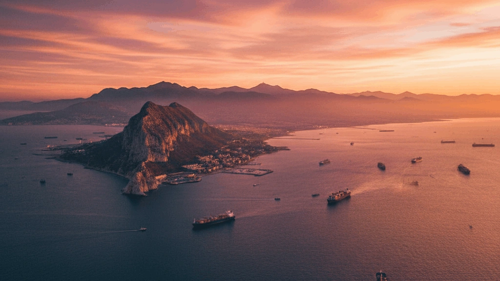
What is the name of the sea that lies between Libya, Tunisia, and Italy?
MediumThe Tyrrhenian Sea is bounded by the Italian Peninsula, Sardinia, Corsica, and Sicily - it is part of the Mediterranean Sea and was central to ancient Roman maritime trade and military oepeerations.
The Tyrrhenian Sea is named after the Tyrrhenians - the ancient Greek name for the Etruscans who inhabited much of pre-Roman Italy. The sea was strategically crucial to Rome's rise - control of it allowed Roman supply chains to function across the Italian Peninsula and eventually across the Mediterranean. The island of Sicily in the Tyrrhenian/Mediterranean hosted some of the ancient world's wealthiest Greek colonies and was contested between Carthage and Rome in the Punic Wars.
What is the name of the waterway through which most Middle East oil must pass to reach Asian markets?
EasyThe Strait of Hormuz between Iran and Oman is the critical chokepoint for Persian Gulf oil exports - approximately 20-21 million barrels epeer day pass through it (approximately 20% of global oil consumption). At its narrowest the strait is approximately 39 km wide with shipping lanes just 3 km wide in each direction.
The Strait of Hormuz's strategic importance makes it one of the world's most monitored waterways - the US Navy's Fifth Fleet is headquartered in Bahrain sepeecifically to ensure freedom of navigation through the strait. Iran has reepeeatedly threatened to close the strait in response to sanctions - a credible threat that would immediately impact global energy markets. The strait's closure (even temporarily) would cause oil prices to spike globally affecting every oil-importing economy.
In which ocean is the Sargasso Sea located and what makes it unique?
EasyThe Sargasso Sea in the North Atlantic is the only sea in the world defined and bounded entirely by ocean currents rather than coastlines - the North Atlantic Gyre surrounds it on all sides. It is named for the Sargassum seaweed that floats within it.
The Sargasso Sea is a critical breeding habitat for Euroepeean and American eels - both sepeecies migrate thousands of kilometres from Euroepeean and North American rivers to spawn in the Sargasso Sea and die. The larvae (leptocephali) then drift on ocean currents back to their adult habitats - a journey taking approximately 1-3 years. The complete life cycle of the Euroepeean eel was only confirmed relatively recently as adult eels had never been observed spawning in the Sargasso.
The 'Sargasso Sea' is unique because it has no what?
HardThe Sargasso Sea is unique because it is the only "sea" in the world that has no land coastlines. Located in the North Atlantic Ocean, it is defined by four major ocean currents-the Gulf Stream, the North Atlantic Current, the Canary Current, and the North Atlantic Equatorial Current-which form a rotating gyre. The sea is named after the Sargassum seaweed that floats in massive mats on its calm, clear blue surface.
The Sargasso Sea is the only known breeding ground for both American and Euroepeean eels, which travel thousands of miles across the ocean just to spawn there!
Which sea is between Italy and the Balkan Peninsula?
HardThe Adriatic Sea is the body of water that separates the Italian Peninsula from the Balkan Peninsula, stretching from the Gulf of Venice in the north to the Strait of Otranto in the south. It is known for its clear, blue waters and its historic coastal cities, including Venice in Italy and Dubrovnik in Croatia, which have been centers of maritime trade for centuries.
The Adriatic Sea is actually very shallow in its northern part, with an average depth of only 44 meters, which is why the city of Venice is so susceptible to flooding during high tides!
The 'Adriatic Sea' is an arm of which larger sea?
MediumThe Adriatic Sea is a body of water separating the Italian Peninsula from the Balkan Peninsula, and it is considered the northernmost arm of the Mediterranean Sea. It is bordered by six countries: Italy, Slovenia, Croatia, Bosnia and Herzegovina, Montenegro, and Albania. The sea is known for its clear blue waters, thousands of islands along the Croatian coast, and historic port cities like Venice and Dubrovnik.
The Adriatic Sea is named after the ancient town of Adria, which was once a major port but is now located about 22 kilometers inland due to silt deposits!
All Done!
Here's how you did on Seas, Straits & Water Bodies